Drone Surveys Near Me
Thermal Imaging Survey
A radiometric thermal reading of the roof or building, alongside the visual pass, for heat loss, damp or a leak that hasn't been traced yet.
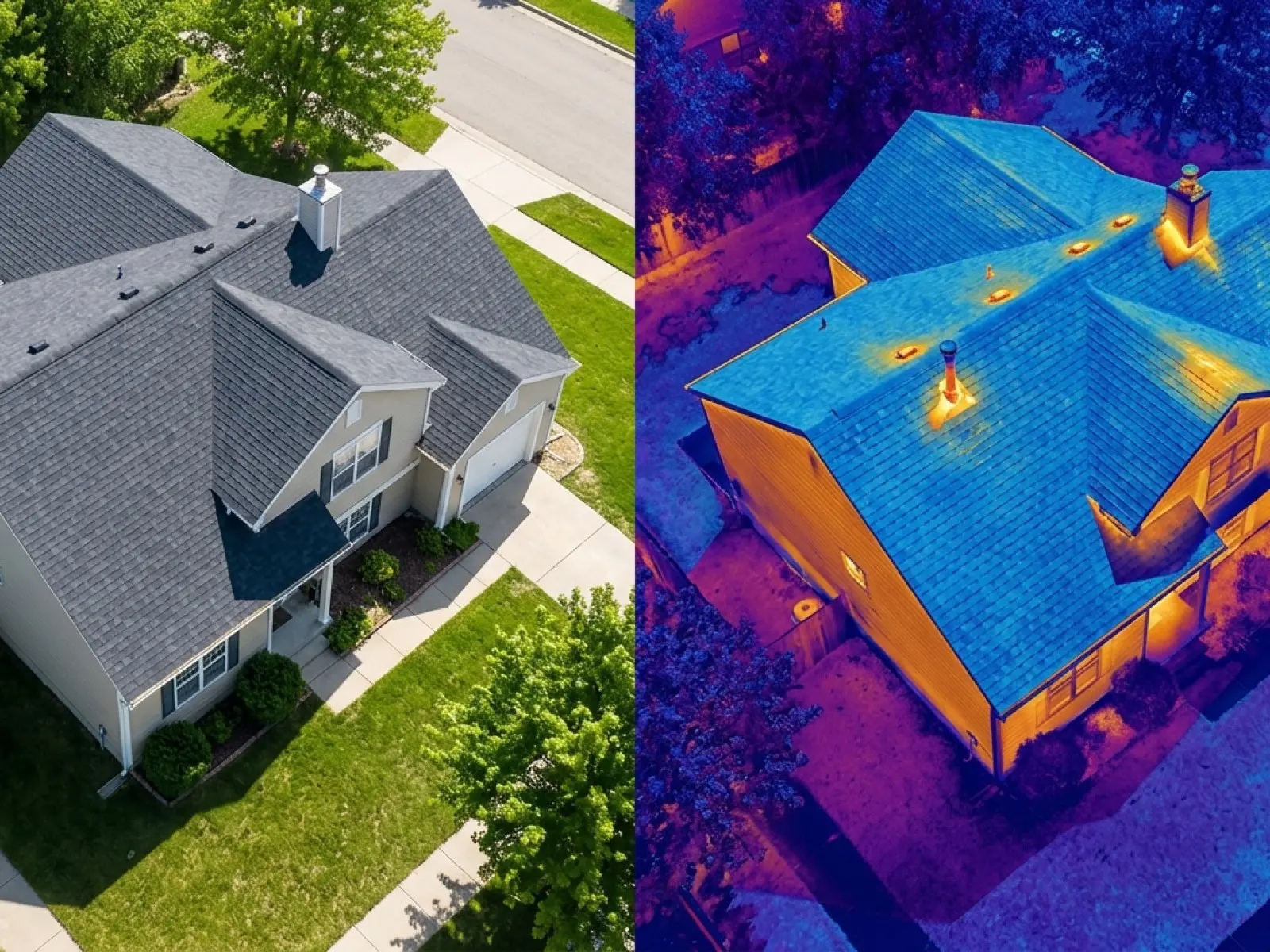
The DJI Mavic 2 Enterprise Advanced carries a 640 by 512 radiometric thermal camera alongside its visual one, so a thermal survey reads actual temperature differences across a roof or wall rather than surface appearance.
That's the right tool for heat loss, a suspected damp patch, or a leak that hasn't been traced to a specific point yet, where the visual picture alone doesn't answer the question.
What is included
- A radiometric thermal pass alongside the standard visual images
- Temperature-difference imagery highlighting anomalies
- A written report within 48 hours explaining what the thermal reading shows and does not show
- Fixed price agreed before the visit
What decides whether a reading can be trusted
A thermal reading is only as good as the conditions it was taken in. A recently sun-warmed roof, a wet surface, or reflective cladding can all produce a misleading picture, so timing (often dawn, after a cold, clear night) matters more for this survey than for a standard visual one.
The report is written to say what the reading actually supports, not to overstate a temperature difference that conditions on the day could equally explain.
On the day
How a thermal survey runs
- Step 1
Confirm the question
Heat loss, damp, or a specific leak: the brief decides how the flight is planned.
- Step 2
Timing checked against conditions
Thermal readings depend on the weather and time of day, not the calendar, so the flight is scheduled around conditions that will actually produce a usable reading.
- Step 3
The flight
Both the thermal and visual cameras cover the same ground, so one is read against the other.
- Step 4
The report
A written report within 48 hours sets out what the thermal camera found, and is plain about what it can't prove on its own.
Behind the work
Kit, cover and qualifications
CAA registered
Registered operator with the Civil Aviation Authority, Operator ID and Flyer ID held.
A2 Certificate of Competency
The qualification that governs how close and how the aircraft can be flown near people and buildings.
Insured with Coverdrone
Fully insured for commercial drone operations, cover confirmed before every job.
Mavic 4 Pro
100 megapixel Hasselblad camera and 6K video for the visual survey.
Mavic 2 Enterprise Advanced
640 by 512 radiometric thermal camera, carried alongside the visual aircraft.
No scaffolding, no ladders
Every survey is flown from the air, whatever the property or the postcode.
Construction background
A construction industry background behind the camera, not just a photography one.
Written report within 48 hours
Every survey, wherever it was flown, comes with a written report inside 48 hours.
Thermal survey
Thermal Imaging Survey questions
- Can thermal imaging find any leak?
- It reads temperature difference, which often points towards where water is getting in or where insulation is missing, but it is one part of the evidence rather than a finished diagnosis on its own.
- Does the weather affect a thermal survey more than a normal one?
- Yes. Timing against recent weather and time of day matters more here than for a standard visual survey, so a thermal booking is planned around conditions rather than a fixed slot regardless of forecast.
Where
Thermal Imaging Survey across the South West
Also on this site
Call now
Check availability with Drone Surveys Near Me
Tell us the address and what you need looking at. Sam Hembury will come back with a fixed price and the next available slot.